


ពីនេះ ពីនោះ
×![]()
ដោយ: ថ្មីៗ
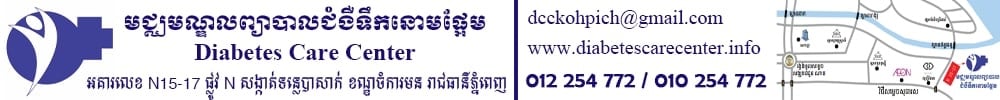
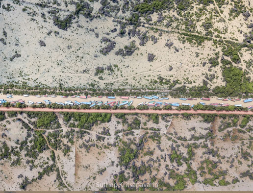
រូបភាពថតពីលើអាកាសទាំងពីរនេះ គឺស្ថិតនៅក្នុងទីតាំងតែមួយ ដែលបានបង្ហាញពីទិដ្ឋភាពក្នុងរដូវប្រាំង និងរដូវវស្សា ទីដែលក្រុមទូកទេសចរណ៍ នៅកំពង់ភ្លុកចូល សុំចត។ នៅក្នុងតំបន់នេះ មានទឹកជន់លិចដោយសាររបបទឹកពីបឹងទន្លេសាប ដែលពង្រីកវិសាលភាពក្នុងរដូវវស្សា។ ផ្លូវលំមួយខ្សែស្ថិតចំកណ្តាលនេះ ត្រូវបានលើកឡើងខ្ពស់ ដែលមានកម្ពស់ប្រមាណ ២-៣ ម៉ែត្រ ដើម្បីអាចប្រើប្រាស់បាននៅក្នុងរដូវទឹក ជំនន់។ ទោះយ៉ាងណា រយៈពេល១០ឆ្នាំចុងក្រោយនេះ កម្រិតកម្ពស់ទឹកនៅក្នុងបឹងទន្លេសាប និងទន្លេមេគង្គមានការផ្លាស់ប្តូរយ៉ាងខ្លាំង។ ឆ្នាំខ្លះនៅក្នុងតំបន់នេះ មិនត្រូវបានជន់លិចដោយទឹកជំនន់ទេ ដោយសារតែវិសាលភាព និងទំហំបឹងទន្លេសាប រួមតូច។ ទាំងអស់នេះ គឺបណ្តាលមកពីបញ្ហាប្រែប្រួលអាកាសធាតុ គម្រោងសាងសង់ទំបន់វារិអគ្គិសនីនៅតាមដងទន្លេមេគង្គ។
These two images photographs on the same location where tourist boats from Kampong Pluk park during the dry season and raining season. The area are flooded cause by the expansion of Tonle Sap Lake during raining season. The road in the middle had been lift up recently several meters to able to use during the flooding period.
However, during the last ten years the water level of the lake and Mekong River had been changed dramatically. Some years, the area didn't flood at all and the lake become very small during the dry season. This possible cause by climate change and hydropower dam projects on the mainstream Mekong.
(អត្ថបទ និងរូបភាពដោយ Suthep Kritsanavarin / USAID Wonders of the Mekong).

© រក្សាសិទ្ធិដោយ thmeythmey.com


«ប្រេសិត»មានន័យដូចម្តេច?
4 ថ្ងៃ